


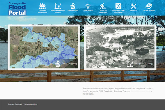
Corangamite Flood Portal
CeRDI has developed the Corangamite Flood Portal as part of its long-term collaborative research partnership with the Corangamite Catchment Management Authority (CCMA). The Flood Portal brings together information for stakeholders on floodplain management within the Corangamite Region, including an interactive flood report, and provides the opportunity for stakeholders to input into the Corangamite Regional Floodplain Management Strategy.
 |
Background
The Corangamite Flood Portal is part of the long-term research collaboration between CeRDI and the CCMA which has existed for more than ten years; other Projects include the Soil Health Knowledge Base, Natural Resource Management (NRM) Planning, Waterwatch and EstuaryWatch.
The Corangamite Flood Portal brings together information for stakeholders on floodplain management within the Corangamite Region. It includes information on:
- Planning Overlays that relate to flooding and which affect properties and development;
- The Regional Floodplain Strategy, and opportunities for the community to contribute to this Strategy;
- The approvals process required for works on designated waterways;
- Websites for warnings related to flooding;
- Emergency contact information for flooding;
- Frequently asked questions in relation to flooding and floodplain management; and
- Additional resources.
The Corangamite Flood portal will assist the CMA, in collaboration with the Victorian State Emergency Service ![]() and the nine local governments in the Corangamite region to develop a Regional Floodplain Management Strategy. The strategy is the starting point for councils and other stakeholders to identify priority flood management activities, which may include flood warning systems and flood emergency response to local needs, improving flood overlays in land use planning schemes, and dealing with riverine, coastal, and urban storm water flooding issues.
and the nine local governments in the Corangamite region to develop a Regional Floodplain Management Strategy. The strategy is the starting point for councils and other stakeholders to identify priority flood management activities, which may include flood warning systems and flood emergency response to local needs, improving flood overlays in land use planning schemes, and dealing with riverine, coastal, and urban storm water flooding issues.
The Flood portal is one of the opportunities offered by the CMA for communities to provide information and feedback. Local knowledge is critical to understanding flood behaviour and options for flood mitigation. Community information will be integral to the development of the Regional Floodplain Management Strategy and setting regional and local priorities for flood management.
Outcomes
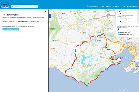
The Flood Portal includes an interactive reporting functionality which allows a user to search for a particular address, obtain a property report and visually identify flood information related to that address.
 |
Innovation
The technology underpinning the flood report functionality combines several Open Geospatial Consortium (OGC) ![]() standards in an innovative fashion. While not displayed visually, the gridded data surfaces from the numerous flood studies throughout the region have been imported into the CeRDI Geoserver instance as Web Coverage Services (WCS).
standards in an innovative fashion. While not displayed visually, the gridded data surfaces from the numerous flood studies throughout the region have been imported into the CeRDI Geoserver instance as Web Coverage Services (WCS).
When a user clicks on a property, the application requests the property boundary as a Geography Mark-Up Language (GML) object from the VicMap Property WFS (Web Feature Service), the map then passes this geometry to a Geoserver-based Web Processing Service (WPS) designed to perform raster analysis on a defined coverage. The WPS returns statistics (min, max, average) from the raster coverage within the bounds of the defined geometry.
As there are several grids for Flood Depth (m), Flood Height (mAHD), and Velocity (m/s), and flood studies can overlap, the WPS is called several times. The application compiles the Minimum and Maximum values and presents them to the user in the report.
Technical Features
The main technical features are listed below:
- Mapping portal with customised layer querying functionality.
- Web to Portable Document Format (PDF) report generation (including embedded map views)
- Ability to provide feedback on the Floodplain Strategy associated with a map location.
- Saved map views
- Resources library
- FAQs and glossary
Approach
As distinct from many of CeRDI's other mapping portals, the intention of the flood map was to focus specifically on a small number of key extent layers, deliberately hiding the detailed flood study layers and using them only in the report statistics generation.
The aim was to make it as simple as possible for a landowner to generate a report on their property.
Additionally the CMA was able to provide the expertise of their Geographic Information System (GIS) analyst to the project who was a vital cog in liaising with the CMA flood officers and in preparing and loading the grids into the portal. This allowed the CeRDI technical team to focus on the functionality of the mapping application.
Future Directions
The portal currently only reports on riverine flooding, coastal inundation grids will be added once the data is harmonised. Visualisation of the flood grids may also be added in a future version of the portal.
