


Visualising Victoria’s Groundwater
Visualising Victoria’s Groundwater (VVG) is an innovative technology offering a real-time, centralised site for Victoria’s ground water information, a resource normally invisible to the public. VVG consolidates data from over 400,000 bores from four authoritative sources together with Victorian aquifer information with features that include spatial visualisations, hydrogeological models and historical records and maps. In 2018, an updated and modernised VVG portal was launched offering extensive new functionality and content.
 |
Background
VVG was launched in July 2012 offering an intraoperative spatial information portal that federates groundwater data from disparate sources. Until the project’s commencement, information about Victoria’s groundwater data was difficult to locate and was stored in various databases with only a fraction of the information available online.
Using the interoperable technologies and high-speed broadband CeRDI was able to successfully capture, aggregate and spatially depict Victoria's groundwater systems within one comprehensive and publicly accessible web portal. This ease of access and exploration of Victoria’s groundwater data allows VVG to be readily adopted by water users, resource managers, landowners, and conservation groups to inform their decisions about managing consumptive water use and environmental water flows.
VVG won wide acclaim from the technology and science industries culminating in several awards, and publications of note, for the industry. The success of the VVG project has also led to collaboration with Open Geospatial Consortium on the development and trialling of international standards in the ground water mark-up language GWML2.
During 2018 an updated and modernised Visualising Victoria’s Groundwater (VVG) portal was developed. It was officially launched in April at a meeting of the International Association of Hydrogeologists (Victorian Chapter) by CeRDI’s Associate Professor Peter Dahlhaus.
 |
Outcomes
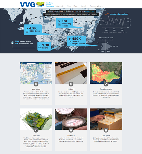
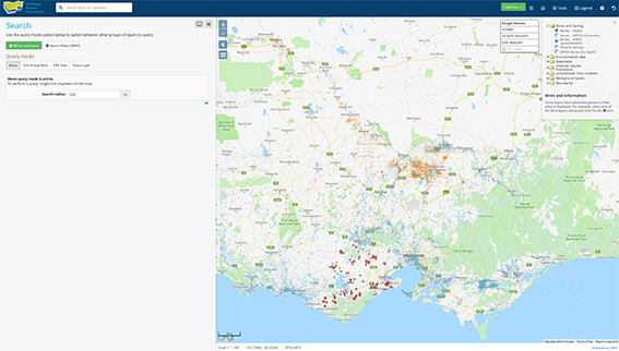
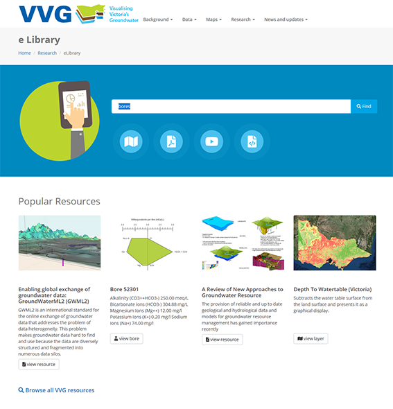
Principal research fellow Associate Professor Peter Dahlhaus and the CeRDI team have worked extensively on developing the new portal and expanding its usability and functionality. Significant upgrades include an online library of resources / e-Library ![]() (pictured below), a spatial map interface
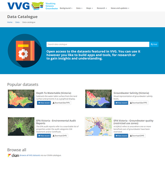
(pictured below), a spatial map interface ![]() (pictured above), and a Comprehensive Knowledge Archive Network (CKAN) data download catalogue
(pictured above), and a Comprehensive Knowledge Archive Network (CKAN) data download catalogue ![]() (pictured below).
(pictured below).
 |  | |
Innovation
The latest VVG portal was created as an ongoing experiment in data democracy. It helps provide the evidential basis for community debates around the groundwater impacts of energy resource developments, urbanisation, and changing climates.
The portal has been increasingly used by the groundwater industry professionals, government agencies, researchers, and the public.
CeRDI was a participant in the interoperability experiment as part of the development of the Groundwater Mark-up Language version 2 (GroundWaterML2) initiated by the Open Geospatial Consortium (OGC). As a testbed for the official OGC interoperability experiment, CeRDI worked closely with other participants to ensure the standard was implementation ready.
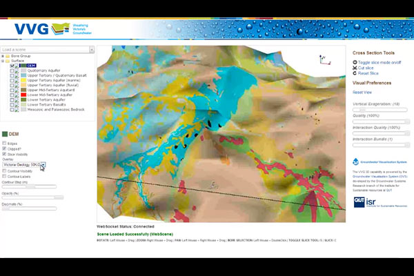
The web-based 3D Visualisation component of the VVG portal was developed in collaboration with the Groundwater Visualisation team at QUT. The system was able to deliver the 3D rendering power of the GVS desktop system via a web browser for the first time. Newly available browser technology (HTML5 web-sockets) was used to allow the user to interact with the remote 3D server which was able to stream the 3D scene in real-time.
Technical Features
Spatial data infrastructure (SDI) has been developed and deployed to federate groundwater data from disparate database sources into a single web portal thereby making data more easily discoverable.
In collaboration with the project partners and stakeholders, the VVG portal was designed to include the following features:
- user requests will be fulfilled via real-time access to remote databases by integrating the interoperable web services they each provide;
- the data resides with the data managers (ensuring currency and validity);
- it has a spatial map function that is intuitive to use (similar to Google Maps);
- all forms of data are included – vector, raster, text, and multimedia;
- data downloads are allowed (subject to data custodian's consent);
- spatial data entities link to the original source documents and images;
- it is capable of dynamically synthesising the data;
- interactive 3D visualisations can be created for user-selected scenes;
- users can add, edit, or update data (subject to quality assurance and quality control);
- the spatial data and models are credible to the user.
Approach
VVG has changed both the way consultants in the groundwater industry work, and how the sector provisions data to assist both the private and public sectors.
The Visualising Victoria’s Groundwater (VVG) portal is setting new standards in user access and functionality. Justifiably, it has won numerous industry best practice awards. Its rapidly growing use is a result of its ability to federate a diverse range of data, its ease of accessibility and the quality of the data. The frequency of use and repeat visitation rates testify to its value and it is a tribute to the CeRDI team’s efforts.
MR BRUCE SIMONS, CSIRO.

RESEARCH OUTPUT
Dahlhaus, P.G., Murphy, A., MacLeod, A., Thompson, H., McKenna, K., Ollerenshaw, A. Making the invisible visible: the impact of federating groundwater data in Victoria, Australia J. Hydroinformatics (March 2016) 18 (2) 238-255; DOI: 10.2166/hydro.2015.169

Brodaric B., Boisvert E., Chery L., Dahlhaus, P.G., Grellet S., Kmoch A., Letourneau F., Lucido J., Simons B. & Wagner B. 2018. Enabling global exchange of groundwater data: GroundWaterML2 (GWML2). Hydrogeology Journal, 26/3, pp.733-741; DOI: 10.1007/s10040-018-1747-9

NEWS
Why should we care about ground water? - 10 July 2025
In May, the Friends of the Barwon delivered the third webinar supporting the Nature Positive Future for the Barwon River System... Continue reading...
Visualising Victoria's Groundwater (VVG) - 10 March 2020
CeRDI's award-winning project VVG is set to benefit from updated data sharing arrangements with two of its primary custodians... Continue reading...
Visualising Victoria's Groundwater web portal relaunch - 13 April 2018
Visualising Victoria's Groundwater (VVG) has been relaunched following significant portal upgrades.... Continue reading...
VVG featured on ABC Country Hour radio - 30 April 2014
Visualising Victoria's Groundwater (VVG) has been featured in a story on ABC radio's state wide program, Country Hour, with presenter Libby Price.... Continue reading...
VVG vying for an Asia Pacific ICT Alliance (APICTA) Award in Hong Kong - 26 November 2013
The University of Ballarat's Visualising Victoria's Groundwater project is being presented as a finalist in the Sustainability and Environmental Technology category at the Asia Pacific ICT All... Continue reading...
National Recognition for Visualising Victoria's Groundwater - 13 August 2013
At a gala event in Melbourne on 8 August, the University of Ballarat became a Merit recipient in the Regional category of the National iAwards for the Visualising Victoria's Groundwater project.... Continue reading...
iAwards Nomination - 16 April 2013
The University of Ballarat's has recently nominated Visualising Victoria's Groundwater (VVG)for a 2013 Regional iAward.... Continue reading...
VVG: A Growing Reputation for Groundwater Resourcing - 16 April 2013
Interest in the University of Ballarat's Visualising Victoria's Groundwater project is growing exponentially, alongside its reputation for successfully managing natural resources data using t... Continue reading...
Seeing is believing: Sharing progress on Visualising Victoria's Groundwater project - 15 October 2012
CeRDI and the University of Ballarat's Visualising Victoria's Groundwater (VVG) project is gaining a reputation as a leader in utilising interoperable technologies to combine and manage natura... Continue reading...
Visualising Victorias Groundwater (VVG) Website launch - 20 July 2012
July 18th 2012. The Visualising Victorias Groundwater (VVG) website has been released to the public. Featuring a unique state-wide map of over 300,000 bores providing user friendly access to all the a... Continue reading...

VIDEOS
Visualising Victoria's Groundwater (10:36)
An interoperative web-GIS that federates groundwater data from disparate sources to assist groundwater researchers and help water managers make the correct choices for the sustainable use of a precious resource. www.vvg.org.au
.

AWARDS
VVG has received wide acclaim from the technology and science industries culminating in several awards including;

PARTNERS
Victorian Government Department of Economic Development, Jobs, Transport and Resources (this department disolved on the 31st December 2018)
Contribution of geological bore database and seamless geology, expertise and advice, test site for data transfers.

Australian National University (Integrated Catchment Assessment and Management Centre)
Co-funder, domain expertise and knowledge, development of research tools, end-use testing.
Southern Rural Water
Contribution of 3D models of the groundwater systems of southern Victoria, data provision, governance, service user.
Victorian Department of State Development, Business and Innovation
Co-funder through BEIP investment.
Victorian eResearch Strategic Initiative (VeRSI)
Expertise and knowledge of research hardware and software infrastructure, technical advice, and development or research tools.

CSIRO
National Geoscience Information Infrastructure - Minerals Down Under FlagshipExpertise and knowledge, especially in the Spatial Information Services Stack and OGC standards.
Goulburn Murray Water
Contribution of knowledge of the groundwater systems of northern Victoria, data provision, governance, service user.
Queensland University of Technology
3D groundwater system modelling and visualisation experts, domain and data expertise.

Natural Resources Canada (NRCan)
Geological Survey of CanadaExpert knowledge of existing eResearch tools, OGC standards, and contributor to developments.
Senversa Pty Ltd
Trial consumers of end-use data and models, advisors on potential uses.

Cooperative Research Centre for Spatial Information (CRCSI)
Contribute expertise and knowledge.