


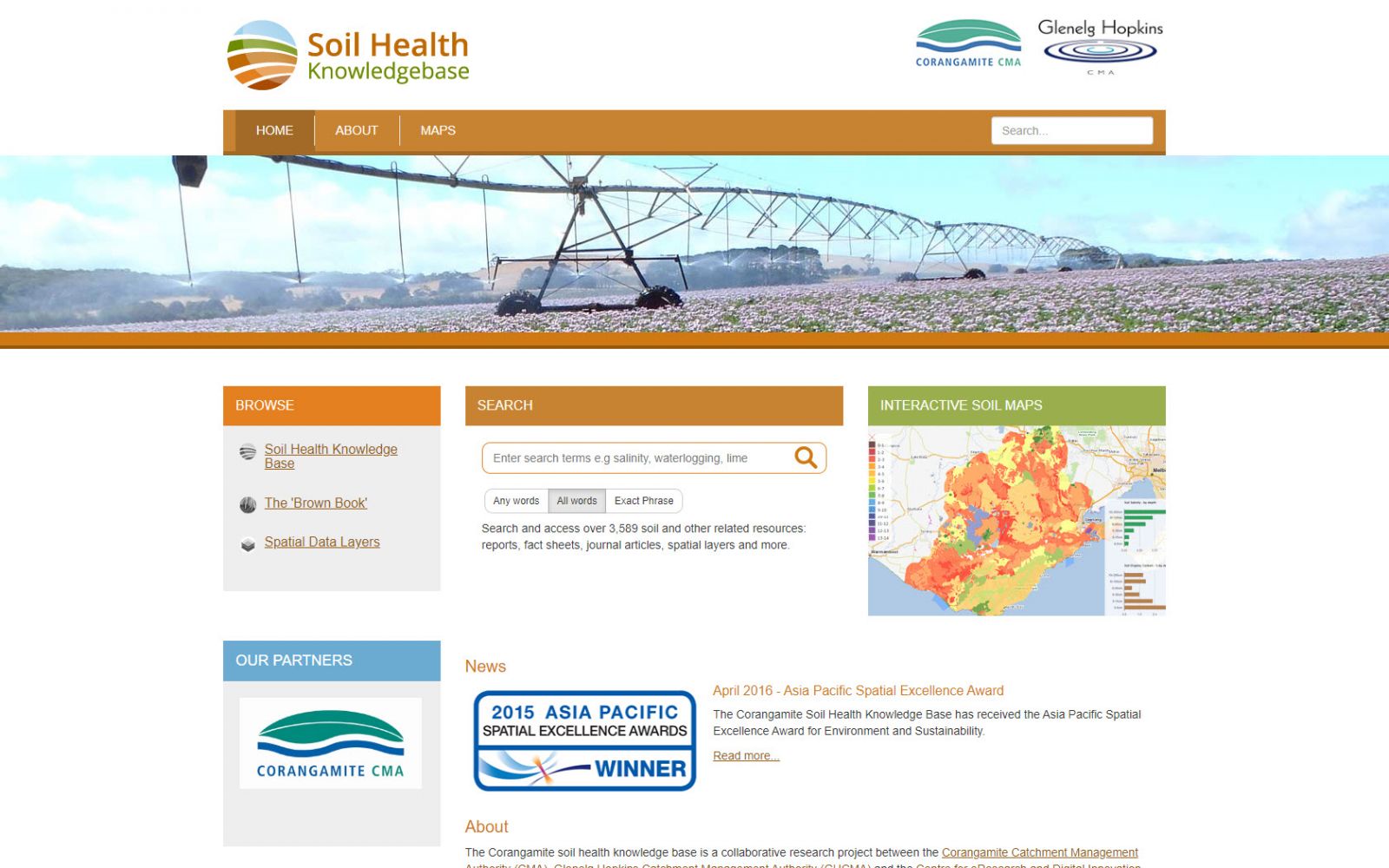
Soil Health Knowledge Base
The Soil Health Knowledge Base is a repository of soil health information for the Corangamite Catchment Management Authority (CCMA) and the Glenelg Hopkins Catchment Management Authority (GHCMA). It assists land managers and other stakeholders to implement catchment management plans across the region. The Knowledge Base was awarded the 2015 Victorian Spatial Excellence Award and the 2015 Asia Pacific Spatial Excellence Award, Environment and Sustainability category.
 |
Background
The aim of the Soil Health Knowledge Base was to develop a comprehensive, informative, intuitive-to-use knowledge base of soil health information that would assist the broader community to better understand the values of the soils of the Corangamite region of Victoria.
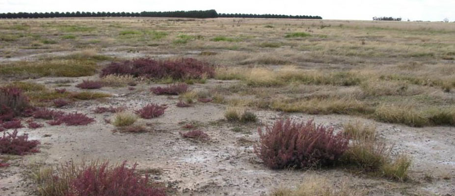
Detailed soil data and information had been collected in the Corangamite region for nearly 80 years: Past data provides valuable baseline data to analyse the veracity and transferability of soil health information.
Commencing in June 2013, the Soil Health Knowledge Base was developed in collaboration with the CCMA and the CCMA's Land Health Program Steering Committee. It assists land managers and other stakeholders to implement catchment management plans across the region.
The Knowledge Base makes accessible a comprehensive range of reports, research papers, maps, soil profiles, soil test data, digital soil maps, land capability maps, geo-hazard maps, hazard susceptibility maps, images, and other resources. It comprises a searchable online library of resources and an interactive map portal.
Outcomes
The mapping portal now provides real-time access to federated soils data from disparate databases held by authoritative sources including Geoscience Australia, the CSIRO Soil and Landscape Grid of Australia as well as legacy data held by government agencies such as the former Victorian Soil Conservation Authority and the Department of Agriculture. Community-contributed soils data from over 100 farm test soil locations sites are included; these enable trends in soil health indicators to be visualised. Soil data from academic research projects is also included e.g., fine resolution digital soil maps from a recently completed PhD project.
The technologies adopted in this project have enabled spatial data, information, and knowledge to be compiled into a single point-of-access, online planning tool that:
- filters data to geographic areas or topics;
- allows the user to add resources, data, observations, and knowledge in any form (e.g., images, text, videos);
- allows data download (subject to the data custodian's consent) and printing; and
- spatially locates and draws plans for on-ground works and then develops proposals guided by templates.
The Soil Health Knowledge Base was awarded the 2015 Victorian Spatial Excellence Award and the prestigious 2015 Asia Pacific Spatial Excellence Award, both in the Environment and Sustainability category.
Innovation
This project led to CeRDI's involvement in a Soils Interoperability Experiment (under the auspices of the Open Geospatial Consortium ![]() ) to harmonise existing global soil information interchange standards and demonstrate the technology to interoperate between disparate systems.
) to harmonise existing global soil information interchange standards and demonstrate the technology to interoperate between disparate systems.
 |
Technical Features
The Soil Health Knowledge Base comprises two main components: an e-Library of digital documents, web pages, images and multimedia that is easily searchable; and an interactive map portal to discover spatial soil data. The map portal is based on spatial data infrastructure (SDI) that has been developed and deployed to federate soils data from disparate database sources into a single web portal thereby making data more easily discoverable.
Where possible, the portal offers real-time access to remote authoritative databases by integrating the interoperable web services they each provide. In cases where the data already exists in other web locations, linked data technologies are used to connect to that remote resource.
Although some data are consumed via interoperable services, there are several datasets hosted and delivered by the Soil Health Knowledge Base. Spatial data engines MapServer (www.mapserver.org ![]() ) and GeoServer (geoserver.org
) and GeoServer (geoserver.org ![]() ) are used for the Geospatial processing and service delivery using Open Geospatial Consortium (www.opengeospatial.org
) are used for the Geospatial processing and service delivery using Open Geospatial Consortium (www.opengeospatial.org ![]() ) standards. Vector data is commonly stored within a MySQL or PostGIS database and raster data is dynamically processed from its native format.
) standards. Vector data is commonly stored within a MySQL or PostGIS database and raster data is dynamically processed from its native format.
Through this project, spatial information systems were adopted to enable users to focus on their geographic region and provide relevant and informative answers to their questions via an intuitive-to-use web-portal.
Approach
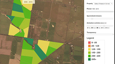
The location summary tool is an excellent demonstration of how CeRDI provides decision useful information relevant to the geographical extent of the user. Once the key datasets were identified, harmonised, and delivered through interoperable technologies, the domain experts were able to work with the technical team to develop report formats which bring together key information from the disparate data-sources. This includes the ability to extract and statistically manipulate raw data into meaningful indicators of soil health. Where private soil test data is provided at the farm paddock scale, the data is averaged from a minimum number of soil-tests within a 5km radius (considering variations in soil landform). The landholder can view their own data in full and make use of the soil property visualisations over time (including farm paddock animations).
Future Directions
- Delivery of soil property observations via Open Geospatial Consortium (OGC) services.
- Crowdsourcing of soil test information
- Continue to integrate and help improve the Digital Soil Mapping (DSM) activities at state, national and international level.
- Increase the level of private soil information included in the knowledge base.
The Knowledge Base provides soil health information to farmers to encourage management practice change to create an enhanced sustainable agricultural sector in south-west Victoria
Mr Bret Ryan, Land Health Manager, Corangamite CMA.
-

RESEARCH OUTPUT
Dahlhaus, P., Nicholson, C., Ryan, B., MacLeod, A., & Milne, R. (2016). Liberating soil data for profitable agriculture and catchment health in the Corangamite region, Australia. 'Soil, a balancing act downunder'. A joint conference of the New Zealand Society of Soil Science and Soil Science Australia. 12-16 December, Queenstown, New Zealand.
Ritchie, A., Medyckyj-Scott, D., Wilson, P., Simons, B., Dahlhaus, P., MacLeod, A., Roudier, P., Gregory, L., & Watson, B. (2016). Developing a global soil data infrastructure - The Open Geospatial Consortium Soil Data Interoperability Experiment. Soil, a Balancing Act Downunder. A Joint conference of the New Zealand Society of Soil Science and Soil Science Australia. 12-16 December 2016, Queenstown, New Zealand. Oral Abstracts, p. 112.
-

NEWS
Federation University and Corangamite CMA win Asia Pacific Spatial Excellence Award - 18 April 2016
CeRDI and the Corangamite Catchment Management Authority were recently awarded an Asia Pacific Spatial Excellence Award which was announced during the Locate16 conference in Melbourne.... Continue reading...
2015 Victorian Spatial Excellence Awards winners - 12 September 2015
CeRDI has been recognised and honoured at the Victorian Spatial Excellence Awards 2015 receiving both the Award for People and Community and the Award for Environment and Sustainability.... Continue reading...

.png)
.jpg)
-

PARTNERS