



Natural Capital Measurement Catalogue Data Visualisation Platform
CeRDI collaborated with Climateworks Centre to develop the Natural Capital Measurement Catalogue  (NCMC) Data Visualisation Platform , an online platform that integrates environmental data from multiple public sources into a single, user-friendly environment. The platform helps organisations access, analyse and report on natural capital, and demonstrates how digital infrastructure can make environmental information more accessible, usable and decision-ready.
Background
Australia has invested heavily in environmental monitoring and data collection, resulting in a vast range of publicly available information on ecosystems, land use, biodiversity, soils and water resources. However, these datasets can be very hard to find because they are widely distributed across multiple platforms, with highly variable metadata. Through an initial collaboration with Climateworks Centre in 2024, CeRDI undertook a systematic review of environmental data sources relevant to natural capital accounting and reporting in Australia, resulting in the identification of over 80 publicly available data sources, which were then linked to metrics within the Natural Capital Measurement Catalogue. Providing these curated data links within the Catalogue can save users substantial time and effort in identifying relevant environmental data sources.
However, significant barriers remained to using these data sources, which often require advanced technical skills to access and interpret. The NCMC Data Visualisation Platform was developed to address this challenge by making natural capital data easier to discover, integrate and use for practical decision-making. Building on the Natural Capital Measurement Catalogue, the platform demonstrates how digital infrastructure can support natural capital accounting, sustainability disclosure and nature-related reporting.
Outcomes
The project successfully demonstrated a practical approach to improving access to Australia’s public environmental data. The platform:
- Brings together 26 datasets from 10 public sources within a single geospatial platform
- Provides non-technical access to nationally significant ecosystem extent and condition datasets
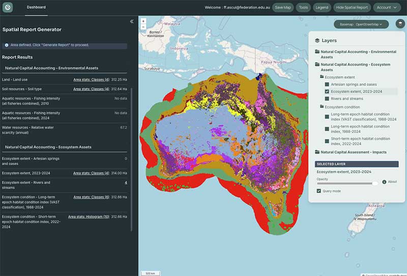
- Enables users to define areas of interest and generate automated summary reports
- Reduces the time, cost and technical expertise required to undertake natural capital assessments
- Received highly positive feedback from stakeholders across finance, consulting, philanthropy and government sectors.
 |
NCMC - Data Visualisation Platform |
Developing a tool that takes organisations from assessing what metrics could be useful to actually capturing outputs from those metrics is really powerful, really helpful and very productive… It takes all that complexity out of it for organisations that don’t necessarily have those GIS skills in house.” - Big 4 consultancy
The way you have linked from metrics to public data sources is really, really good. I think that’s a good precedent that many should follow.” - Government agency
Innovation
The NCMC Data Visualisation Platform demonstrates a new approach to natural capital information infrastructure. Rather than simply cataloguing data sources or displaying maps, the platform integrates diverse datasets into a consistent framework aligned with the Natural Capital Measurement Catalogue and international standards including the System of Environmental-Economic Accounting (SEEA) and Taskforce on Nature-related Financial Disclosures (TNFD). By automating data integration, visualisation and reporting, the platform helps bridge the gap between environmental science and real-world decision-making.
Technical Features
The platform includes a range of advanced yet highly accessible features:
- Interactive map-based interface
- Integration of 26 datasets from 10 public data sources
- Structure aligned with the Natural Capital Measurement Catalogue
- Metadata and links to original data sources for every dataset
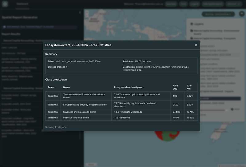
- Spatial report generator for user-defined areas
- Ecosystem extent and condition visualisation
- Land, soil, water and biodiversity layers
- Address search and navigation tools
- Measurement and mapping tools
- Downloadable maps and reporting outputs
 |
NCMC - Data Visualisation Platform |
The platform demonstrates how complex environmental information can be delivered through intuitive digital tools that do not require specialist GIS expertise.
Approach
The project combined expertise in natural capital accounting, environmental data management and geospatial technologies. The development process included:
- Review of existing natural capital accounting tools and platforms.
- Identification and selection of priority datasets aligned with the Natural Capital Measurement Catalogue.
- Development of an intuitive web-based geospatial portal.
- Creation of data ingestion pipelines and automated reporting functionality.
- Stakeholder engagement and testing with representatives from finance, consulting and government sectors.
This approach ensured the platform addressed both technical and user needs while maintaining alignment with recognised natural capital accounting frameworks.
Future Directions
The demonstration platform establishes a foundation for future development. Potential next steps include:
- Expanding coverage to additional NCMC datasets
- Developing automated reporting functions aligned with SEEA, TNFD and other sustainability reporting and natural capital accounting frameworks
- Introducing benchmarking and time-series analysis
- Supporting additional methods for defining areas of interest
- Improving user experience through further testing and refinement
These developments could further accelerate the adoption of natural capital accounting and nature-related decision-making across Australia.

TEAM MEMBERS
Professor Environmental Accounting: Prof Francisco Ascui
Research Fellow - Data Interoperability: Dr Chris Bahlo
Program Delivery Manager: Richard Archer
Senior Systems Analyst Programmer: Indika Sirimanna
Systems Analyst Programmer: Sudeera Abeywickrema
Program Manager: Dr Ross Mann
Centre Director: Distinguished Prof Helen Thompson

NEWS
Turning Environmental Data into Decision-Ready Information - 23 September 2026
How CeRDI is helping build the digital infrastructure needed for natural capital accounting in Australia... Continue reading...