

CeRDI Newsletter Spring 2016
In this issue:
- Message from the Director
- Major Awards for CeRDI
- Launch of Waterwatch and EstuaryWatch
- Agriculture Climate Resilience Project
- Federation University – a key participant in CRC bids
- CeRDI and RMIT collaborate on precision agriculture
- Sport and Recreation Spatial documentary film
- Visualising Victoria’s Biodiversity
- Learning about the migration of Latham’s snipe
- Our Coast website launch
- Southern Farming System Probe Trax
- Pilot project identifying rural alcohol culture and change in the Wimmera
- Health Justice Partnership project
- Staff Profile Birgita Hansen
- Post graduate student news
- About CeRDI
- Contact CeRDI
Message from the Director
 |
|
|
Associate Professor |
|
Welcome to the latest bumper issue of the Centre for eResearch and Digital Innovation (CeRDI) newsletter showcasing recent research and technical innovations.
A highlight in September was CeRDI's double success at the Victorian Spatial Excellence Awards: the Corangamite Natural Resource Management Planning Portal was granted the Award for Environment and Sustainability; and Online Farm Trials won the Award for Spatial Enablement.
The Centre has also been involved in a number of collaborative research projects that have culminated in various project launches. These successful outcomes have been complemented by commencement of research including a data mapping and sharing project with the Wimmera Social Services Community of Practice, and significant involvement in recent funding bids for the CRC for High Performance Soils, Food Agility CRC and collaboration with RMIT on a Global Innovation Linkages program to conduct industry relevant research in the area of precision agriculture.
A range of other stories are included in this issue, highlighting the diversity and breadth of CeRDI's activity.
We hope that you enjoy reading this issue. If you have any comments about our newsletter please get in touch.
Associate Professor Helen Thompson
Director, CeRDI
November 2016
Major awards for CeRDI
.jpg) |
|
|
Left to right: Helen Thompson, |
|
The Centre for eResearch and Digital Innovation (CeRDI) has won two major awards at the 2016 Victorian Spatial Excellence Awards, announced at a gala dinner in Melbourne in September.
CeRDI and its partners won the Award for Environment and Sustainability for the Corangamite Natural Resources Management (NRM) Planning Portal, and also won the Award for Spatial Enablement for Online Farm Trials.
“I congratulate other winners and finalists in the Victorian Spatial Excellence Awards,” CeRDI's Director, Associate Professor Helen Thompson, said. “We are very proud of the spatial and knowledge management research we undertake and I acknowledge and thank my CeRDI colleagues who have been involved in these successful projects. We are committed to working with industry partners to deliver digital and online innovations that support and enhance their work practices. These awards recognise the achievements of CeRDI and its strong and collaborative ties with industry to effectively utilise the latest innovation and spatial technologies to transform industry knowledge”.
Associate Professor Helen Thomson commented that, “As Victorian winners, Online Farm Trials and the NRM Planning portal now proceed as finalists in the Asia Pacific Spatial Excellence Awards, which will be held in Sydney at the Locate17 Conference in April 2017”.
Corangamite Natural Resource Management Planning Portal: Award for Environment and Sustainability
Landcare Groups in the Corangamite Catchment Management Authority (CMA) region are adopting a planning model that could revolutionise how communities work together to care for our environment.The Natural Resource Management (NRM) Planning Portal promotes regional and local knowledge sharing, with intuitive and easy-to-use tools developed to spatially capture local priorities. It enables Landcare networks and partners to form their own local plans, to share and gain access to information and to come up with joint priorities that have the best potential for funding.
Web-based geospatial technologies are empowering Landcare networks and community groups, improving project planning and reporting, supporting communication of agreed landscape zone priorities and enabling long term research, data capture, monitoring and evaluation.
Partners on this project include the Corangamite CMA and 11 Landcare networks in the Corangamite region.
Online Farm Trials: Award for Spatial Enablement
Online Farm Trials (OFT) is a collaborative project putting cropping research knowledge online and linking it to national data, opening up new possibilities for smarter farming and better research.
Research trials conducted on farms have been a part of Australian farming for many years. The research is often instigated by local grower groups on behalf of agricultural communities, and conducted or overseen by government research agencies, research organisations or private industry. Thus, on-farm trials help primary producers improve farming productivity and sustainability by providing ‘real world’ solutions to current cropping problems.
The Grains Research and Development Corporation (GRDC) is the industry partner and project funder of OFT.
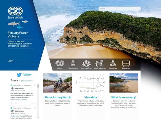
Launch of Waterwatch and EstuaryWatch
 |
|
CeRDI has recently completed development work on two prominent Victorian citizen science programs: Waterwatch, and its sister programme, EstuaryWatch.
Both Waterwatch and EstuaryWatch are well-established, important community engagement programs promoting interest in water issues including sustainability, water management and the health of local waterways and connecting local Victorian communities.
More specifically, Waterwatch facilitates community involvement in river health and sustainable water practices. Waterwatch community members are encouraged to become participants in their local environment through waterway monitoring and ongoing activities.
In a similar vein, EstuaryWatch promotes the monitoring of estuary health and local waterways across 18 Victorian regions, and is supported through involvement of local catchment management authorities.
Both programs rely heavily on community and volunteer contributions to assist with regional data collection and recordings of water quality across Victoria’s rivers and associated waterways.
.jpg) |
|
The recently launched Waterwatch and EstuaryWatch sites provide an essential resource for all members to access current information and data. Both provide access to innovative technical tools and data portals. Core to their functionality are re-designed databases, rapid data interrogation tools and interactive maps for accessing and visualising region-specific data. Further, direct upload and download of data about local waterways estuaries will facilitate more rapid dissemination of each program’s monitoring achievements. Provision of the data as web services in addition to ease of access will enable information to be quickly and easily exchanged between organisations and community groups.
CeRDI has led the redevelopment of these sites with a combination of research and technical team members working with program co-ordinators to ensure maximum value for users. CeRDI’s Dr Birgita Hansen has been the leader on both these projects with significant technical input from Paul Feely, Sudeera Abeywickrema, Heath Gillett and Peter Plucinski. Working closely with project partners and representatives from both programs throughout the redevelopment has maximised outcomes. Already, feedback from users and project partners has been extremely positive.
.png) The next stage for this project is the commencement of a longitudinal program of social research. CeRDI, in partnership with the Corangamite Catchment Management Authority, has appointed a PhD student, Patrick Bonney, to conduct research focusing on the growth of citizen science as an approach for community engagement and the building of knowledge repositories to support practice change, inform policy and environmental management decisions. Patrick commenced his studies on 1 November 2015.
The next stage for this project is the commencement of a longitudinal program of social research. CeRDI, in partnership with the Corangamite Catchment Management Authority, has appointed a PhD student, Patrick Bonney, to conduct research focusing on the growth of citizen science as an approach for community engagement and the building of knowledge repositories to support practice change, inform policy and environmental management decisions. Patrick commenced his studies on 1 November 2015.
Agriculture Climate Resilience Project
 |
|
An extensive impact research study reporting on the South Gippsland Agricultural Climate Resilience Project (ACRP) has recently been completed by Dr Angela Murphy together with a team of researchers from CeRDI.
This research, which was commissioned by South Gippsland Council together with Bass Coast Council, was undertaken to examine the outcomes from a two year project implemented to support climate change adaptation across food producers in the region. The aim of the program was to improve resilience to climate risks through better decision making and effective action on the ground. A range of engagement, educational and information sharing activities were developed and offered to communities across the region. The program was funded by the Victorian Government’s Department of Environmental, Land, Water and Planning (DELWP).
CeRDI’s role was to examine the implementation and uptake of the program across the region using wide ranging research methods that included surveys, interviews and an extensive review of program and secondary data (including post event evaluation responses completed by program participants). The researchers explored the approaches that were most effective in supporting the community, and examined the extent to which project delivery aligned with the program aims that had been established.
Research participants were drawn from a range of food production sectors and from the community. Data analysis confirmed that the program had achieved a measure of success in building levels of awareness of climate change issues and providing strategies to enhance agricultural resilience among participants through engagement activities including place-based learning, partnerships and network building. The range of educational topics and learning approaches were highly valued by program participants: information about agricultural diversity, managing weather and rainfall shifts, biosecurity, financial literacy and soil health were considered topics of high importance by program participants.
The impact research also identified that diverse strategies for awareness building had contributed to the success of the project and developed the communities’ engagement through the program. Farm visits, field experts and hands-on workshops were valued as methods for knowledge sharing. Through its events program, the project assisted in facilitating the building of successful and wide-ranging networks within the broader community. It was also found to assist in partnership development and partnership attainment across the region.
Various recommendations were proposed to assist in the development of similar programs in the future. Researchers from CeRDI believe that the outcomes from this research will be valued by key project stakeholders and that the research learnings have the potential for broader dissemination to inform implementation of agricultural resilience projects in the future.
Federation University – a key participant in CRC bids
Federation University (Federation University) is a key participant in two of the Round 18 Stage 2 Cooperative Research Centres (CRC) bids.
The CRC bid for High Performance Soils (CRC-HPS) is a 10 year research program designed to provide farmers with the knowledge and tools required to make decisions on extremely complex soil management issues. CRC-HPS bridges the gap between soil science and farm management. Federation University’s participation in this CRC involves CeRDI and the Faculty of Science and Technology.
If successful, the CRC-HPS will be developed in collaboration with farmers, industry and researchers providing a suite of practical solutions for on-farm application. It will integrate research across diverse fields, including soil science, big data, sensor technology, nanotechnology, environmental science, social sciences and agricultural and farm management. The CRC-HPS also aims to increase the level of innovation in how Australia manages, protects and values soil assets. This will be achieved through the four integrated programs:
- Programme 1: Investing in high performance soils,
- Programme 2: Soil performance metrics,
- Programme 3: New products to increase fertility and function, and
- Programme 4: Integrated and precision soil management solutions.
CeRDI will support the provision of research infrastructure for this CRC through specialised computing and information analysis and federating systems, using eResearch approaches. Interoperable technologies will provide greater exposure to the most current and comprehensive economic, environmental and social information and datasets while also making the data available to other portals and applications.
Announcements of successful Round 18 CRC applications are expected before the end of 2016 with funded activities to commence from 1 July 2017.
CeRDI is also a participant in the Round 18 Food Agility CRC. The Food Agility CRC seeks to empower Australia’s food industry to grow its comparative advantage through digital technologies. Faster insights from real-time data and predictive algorithms will help Australian food producers, processors and retailers to more rapidly respond to what the market wants, be more efficient in how they produce and market food, and demonstrate food safety and sustainability to customers. The Food Agility CRC brings together almost 50 participants from food, technology and research sectors and will be guided by agile methods to achieve the CRC vision.
Through engagement in the Research and Innovation Network for Precision Agriculture Systems, Federation University is also actively participating in preparations for the Round 19 Farming Smarter CRC bid.
The Farming Smarter CRC will deliver technology and practice-based farming solutions that drive productivity growth throughout the Australian agricultural sector. The needs of the farming sector will be placed at the centre of its strategic direction, whereby the CRC will bring together stakeholders from all facets of the sector to lead a joint research, commercialisation and technology adoption program in agricultural systems.
Round 1 applications are due to be submitted by 1 July 2017.
CeRDI and RMIT collaborate on precision agriculture
CeRDI is collaborating on a funding bid with RMIT to expand innovation linkages nationally and internationally in the area of precision agriculture. The Smart Digital Platforms for Innovative Precision Agriculture (SmartAg) program will support the development of a suite of innovative platforms and smart systems for next generation agriculture using advanced precise satellite positioning, geographical information system (GIS) and remote sensing technologies.
Cutting-edge unmanned aerial vehicles, information and communications technology (ICT), data interoperability and big data analytics as well as in-situ weather and climate information, soil measurements and crop monitoring will be incorporated to provide robust support for agriculture decision-making across all stages of production.
SmartAg will support a new chapter of agribusiness innovation for both Australia and China, significantly by increasing productivity, technological and service exports and by expanding digital agriculture employment in both the domestic and international markets. Associated developments will allow Australia to be well positioned in the world frontier and ready for Agriculture 2025 and beyond.
Funding outcomes associated with the Global Innovation Linkages program proposal will be announced by AusIndustry in coming months.
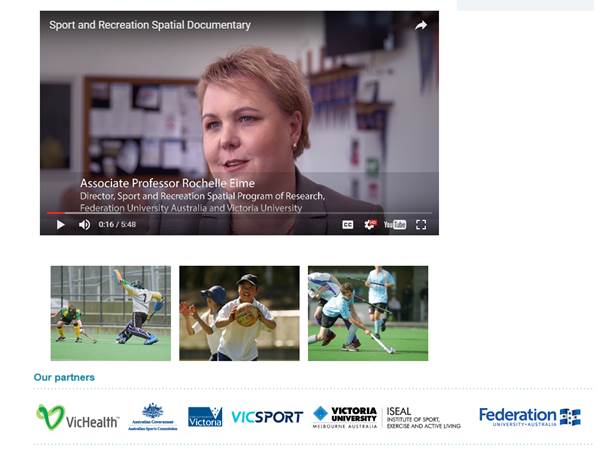
Sport and Recreation Spatial documentary film
.jpg) |
|
A documentary film about Sport and Recreation Spatial has recently been prepared by Wind and Sky Productions. The film, which was launched in October, offers a comprehensive overview of the Sport and Recreation program of research and includes narration by the principal researcher Associate Professor Rochelle Eime.
Sport and Recreation Spatial is a collaborative program of research between the Faculty of Health (Federation University), CeRDI and the Institute of Sport, Exercise and Active Living (Victoria University).
Sport and Recreation Spatial researchers investigate sport and recreation participation, sports facilities and health outcomes. Industry collaboration has supported the establishment of an extensive collection of national and state-wide data covering areas including sports participation, sport and recreation facilities, population demographics and population health from multiple data custodians. The current collection includes over 3.5 million sport participant records from 11 leading sports. Sport and Recreation Spatial data has been analysed and interrogated for a range of research, planning and policy purposes with key project partners including State Sporting Associations, Sport and Recreation Victoria and VicHealth.
A core innovation of Sport and Recreation Spatial is its use of web-based GIS technologies to present spatial data relevant to all levels of the sport and recreation industry. This enables research to be undertaken that addresses industry-relevant questions of national and international significance, to undertake strategic planning, facilities management and to develop recreation participation programs.
 |
|
The documentary film elaborates on how the capabilities and application of Sport and Recreation Spatial support industry and inform practice. In addition to the insights about the research offered by Associate Professor Rochelle Eime, industry partners including from Michael Cahill, Department of Health and Human Services Victoria, Amanda Basu, Netball Victoria, and Rayoni Nelson, VicHealth.
Visualising Victoria's Biodiversity
.jpg) |
|
A new open access community resource called Visualising Victoria's Biodiversity (VVB) was recently launched with the aim of facilitating information sharing and discovery about Victoria's environmental values, conservation activities and research. VVB consolidates access to spatial environmental datasets and information – created and managed by government agencies, organisations, community groups and individuals – into a user friendly and interactive platform.
VB is an initiative of CeRDI, which, under the research leadership of Rob Milne, has been supported by funding from the Helen Macpherson Smith Trust.
VVB offers a range of features for accessing and generating key environmental information with tools available to support:
- generation of lists of environmental features such as flora and fauna records, for a user-selected area of interest;
- map layers in which observations, environmental features, monitoring information and environmental events in any area of Victoria can be viewed and overlayed; and
- information sharing about environmental projects or research.
The extensive spatial data catalogue available on the portal has been compiled from a wide range of sources including key state and national data repositories such as www.data.vic.gov.au, the Victorian Biodiversity Atlas and the Atlas of Living Australia, as well as local and regional information shared by community groups and individuals.
.jpg) |
|
With over 45 map layers currently provided, VVB is revealing the depth and extent of the biodiversity knowledge and data that is available across Victoria. In commenting on the range of information presented on VVB Rob Milne confirmed, “The key purpose of the VVB is to offer the Victorian community and environmental sector improved and easy access to the vast amount of available environmental information to facilitate knowledge sharing, assist research and support decision making”.
The establishment and development of VVB has been informed by the State Wide Integrated Flora and Fauna Teams (SWIFFT), community members and other key organisations and agency stakeholders.
It is anticipated that the data available through VVG will provide local communities and environmental organisations with access to valuable, region specific information. It is also anticipated that the VVB will help inform the development of future environmental research through access to comprehensive data.
Learning about the migration of Latham's snipe
.jpg) |
|
|
Above: A great place to see Latham’s Snipe |
|
A research project using light-level geolocators to obtain information on migratory patterns of the Latham’s snipe (Gallinago hardwickii), a shorebird that migrates to the Japan from Australia, has resulted in the first ever full migration track for the species.
The research is being coordinated by Dr Birgita Hansen, a research fellow at CeRDI. The Lathan’s snipe project team has been working collaboratively with colleagues from the Wild Bird Society of Japan (WBSJ). Close connections with Japan have been forged through this project, and the Australian research team recently visiting members of the WBSJ in Hokkaido to conduct snipe research.
The Latham’s snipe research commenced in October 2015 with the capture and tagging of Latham snipe in Port Fairy, south-west Victoria. Data loggers called geolocators that record day length, were deployed on birds. Recapture of birds is required to retrieve the light data from the logger.
On 9 October 2016, Birgita and colleagues re-captured the first tagged bird (T0) only a few hundred metres from its original capture site, 12 months previously. The geolocator appeared in good condition and the bird was in good health.
The device from T0 yielded a full year of light data, which was analysed to determine the latitude and longitude of the bird over that period. Data shows that T0 left Port Fairy in February 2016 and spent about two months in south-east Queensland before flying to Cape York (or somewhere in that region) in April. From there the bird flew direct to Hokkaido and arrived early May. The bird may have incubated a clutch whilst on the breeding grounds somewhere in southern Hokkaido, over May–June. In late August it flew direct from Hokkaido back to South-east Queensland in three days. This distance is approximately 7000km, meaning that may represent one of the fastest bird flights on record at over 90km/h. Once back in Queensland, T0 spent a well-earned month presumably recovering its energy reserves before returning to Port Fairy on 26 September 2016. A full migration track for the snipe is included in the map opposite.
.jpg) |
|
This is the first time a migration track has been obtained in this manner from Latham’s snipe. This capture confirms early hypotheses based on years of observation by the South Beach Wetlands and Landcare Group project team members that some snipe return to Powling Street wetlands in Port Fairy each year. The research team are therefore hopeful they may recapture another of the 14 geolocator-bearing birds from 2015.
Birgita would like to thank the extremely hard working and dedicated team in Port Fairy and volunteers on catches over the last 13 months. Thanks also to the Victorian Wader Study Group for supporting the project and the Australia Japan Foundation for funding to cover geolocators and the visit to Japan.
Our Coast website launch
.jpg) |
|
The Our Coast website, developed at CeRDI, was launched earlier this year in Geelong by Water Minister, the Honourable Lisa Neville.
The Our Coast website offers local government and communities in the Bellarine Peninsula and Geelong information about planning for a changing climate and the local environmental impacts this change may exacerbate, such as rising sea levels, storm surges and coastal erosion.
The project has an extensive community engagement focus and was supported by the Victorian Government, the City of Greater Geelong, the Borough of Queenscliffe and local committees of management.
A series of community information sessions have been conducted in each of these areas enabling community members to learn more about the coastal data and the predicted scenarios relating to sea level rises over the next 50 years. Session attendees have learnt about possible implications of rising sea levels and have been provided with the opportunity to provide input into future planning initiatives.
The Geelong and Bellarine Peninsula study area is one of four similar coastal assessment projects across Victoria. Related initiatives are being conducted nation-wide, offering coastal assessments and mapping to provide communities with a fuller understanding of the potential impacts of climate change along Australia’s coastlines.
CeRDI’s role within the project included the development of a simple coastal impact solutions tool (http://www.ourcoast.org.au/solution_matrix.php), with Data61 involved in the development of a number of visualisations (available as Videos on the resources page).
Southern Farming System Probe Trax
 |
|
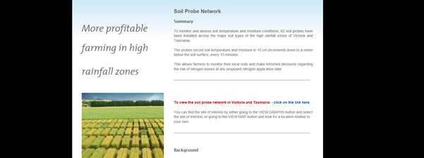
Southern Farming Systems (SFS) have a 20 year history of delivering programs to farmers and advisors across southern Victoria and Tasmania. Recently SFS have teamed with the Corangamite Catchment Management Authority (CCMA) to deliver projects and services through Landcare networks in the region. SFS have been responsible for the successful completion of the two large projects that established a soil moisture probe network and initiated a fee-for-service arrangement with farmers to ensure the probe network is maintained.
Although the soil moisture probe network was capable of generating significant data, it was recognised that the adoption would be limited unless SFS could deliver soil moisture and temperature information in a way with was user friendly and decision useful for farmers.
Research collaboration with CeRDI was subsequently initiated by SFS to identify how the utility of soil moisture probe data across south-eastern Australia could be maximised by better understanding the decision support required by farmers and their advisors.
The project involved four key phases:
 |
|
- development of a user friendly decision support interface for web, mobile phone and tablets with push notification,
- development and delivery of workshops to farmers, advisors and Landcare groups,
- development of a 'how to guide' for the wider public outlining information about accessing data and decision support resources and facilitate discussion, and
- evaluation to understand the impact of the project and to enable further improvements.
This project will enable farmers and advisors to make more informed decisions about their farming practices based on access to soil moisture and temperature information. An existing network of 60 probes located throughout southern Victoria and Tasmania is disseminating real-time information about soil conditions, enabling critical decisions to be made about crop and pasture growth. Through this, the project is facilitating access to the decision support interface and tools that assist farmers in monitoring soil moisture conditions, interpreting results, setting alerts and taking action.
There is significant potential for learnings from the SFS Soil Probe Network project to be extended through future research and technology developments and workshops directed towards other Internet of Things (IoT) technologies such as weather station or drone data. There may also be potential for learnings to inform practices in areas other than farming, with interest already received from state-wide authorities and organisations who monitor soil moisture data to assist in predicting potential fire risk or nutrient runoff into waterways and storages.
A video explaining the SFS Probe Trax program is available at https://www.youtube.com/watch?v=qLCiSscIzXw with further information available at: www.sfs.org.au/ProbeTrax_MoistureProbeNetwork
Pilot project identifying rural alcohol culture and change in the Wimmera
CeRDI has been commissioned to conduct research and to promote cultural change towards alcohol use for youth in Horsham. Under the research leadership of Dr Angela Murphy, this project has been funded through VicHealth’s Alcohol Culture Change Grants for Local Councils. Horsham Rural City Council (HRCC) was one of eight council’s state-wide to receive funding for a pilot study to assess alcohol culture and identify potential health interventions leading to cultural change and safer, reduced alcohol consumption for young people in the region.
The research involves a desktop review of current literature together with a comprehensive local data collection strategy that will involve surveys and focus group meetings with representative agencies across the region and with young people. The project seeks to capture insights that will form an understanding of the current practices of alcohol consumption and alcohol misuse in the region. It is expected that information will allow for identification of opportunities for cultural change to reduce alcohol use.
The research will be completed early in 2017. It is anticipated that the insights from this research will assist the region to inform change pertaining to the cultural ‘norms’ associated with alcohol consumption for young people in rural areas. Once this stage of the research is complete there is the potential for additional funding through VicHealth for an extension of the project. Research outputs including peer-reviewed journal papers are anticipated, with the data likely to offer fresh insights into alcohol use amongst young people in rural regions.
Health Justice Partnership project
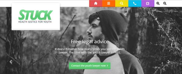 |
|
The Health Justice Partnership for Youth is a program delivering an integrated health justice service for young people in the Central Highlands, and has been operational since mid-2015. The collation of program data from research conducted by researchers at CeRDI and partner agencies is offering valuable insights about the impact of the program on young people in the region.
The Health Justice Partnership for Youth is a collaboration between CeRDI, Ballarat Community Health (BCH) and Central Highlands Community Legal Centre (CHCLC). It has been funded by a major grant from the Victorian Legal Services Board.
The program delivers an integrated medical and legal service with a lawyer from CHCLC based across all sites at BCH. The program provides early intervention for legal and health issues to improve the outcomes for disadvantaged young people experiencing multiple health and legal issues.
Program data and research to date provides insights about service usage and its uptake. Since its commencement, over a 110 young people aged 15–25 years have received services through the program; many have attended the program with at least one legal problem – and in some instances, with two or three issues. Legal issues that young people have attended the service with have been wide ranging and include criminal, civil and family matters. Survey data about the program from the young people themselves indicates that for many, the legal problem was impacting on other aspects of their lives. Internal and external agency referrals have been very strong, indicating a breadth of awareness and understanding of the project and in sharing positive insights they have observed in the young people that they have referred to the service. The final wave of research for the program will commence soon, with results to be finalised in early 2017.
With program funding to cease at the end of the year, a series of workshops to explore ongoing funding options for the program is currently underway. Key stakeholders are being informed about the success of the program through project sustainability workshops. Project leader and research fellow at CeRDI, Dr Margaret Camilleri, is keen to explore the options to ensure the program continues, commenting that: “The research collected offers evidence that the Health Justice Program is meeting a void in the community by offering young people support with their legal and health issues. It is important that this program is extended so that it continues to meet the health and legal needs of young people in the region, delivered importantly, through an integrated yet flexible service model”.
Staff profile
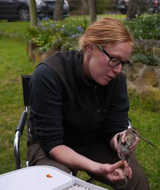
Dr Birgita Hansen, Research Fellow
 |
|
Dr Birgita Hansen has research interests and expertise in improving the science and practice of restoration and the conservation of biodiversity in agricultural landscapes. She has many years’ experience in the field of ornithology, specialising in waterbirds and wetlands. Her research has made an important contribution to policy and planning in fields of conservation genetics, management of streamside zones and waterbird conservation.
In her current role at CeRDI, Birgita is applying her experience to the development of spatial information systems for biodiversity knowledge management, climate adaptation, natural resource management and citizen science.
Birgita’s key projects include the recent re-development of the Waterwatch and EstuaryWatch. These citizen science programs aim to engage the community with waterway and estuary monitoring, and both play an important role in catchment planning. Birgita used her experience from stream and estuarine ecology to guide content management and data reporting. Working with her environmental research colleague Rob Milne and the CeRDI technical team, Birgita has contributed to the expansion of the NRM Planning Portal, SWIFFT and linked mapping portal, VVB. In collaboration with Faculty of Science and Technology vegetation researchers Nick Schultz and Megan Good, she has guided the development of a new portal for crowd-sourcing data on symptoms of tree health decline in South Australia (SA Tree Watch).
Birgita recently lead an ambitious project for BirdLife Australia and the Commonwealth Department of the Environment, to revise the flyway population estimates of 37 migratory shorebird species in Australia. This foundational work, completed by a team of leading Australian shorebird researchers, will be used to update the key piece of environmental policy in Australia, The Environment Protection and Biodiversity Conservation Act.
Birgita has a long-standing history of working with volunteers in shorebird conservation. She is the Treasurer of the Australasian Wader Studies Group (a special interest group of BirdLife Australia), and a licensed cannon-netter and long-term volunteer member of the Victorian Wader Study Group.
In addition to her CeRDI projects, she is leading a collaborative project investigating the movement patterns and habitat use by Latham’s snipe. This study combines the knowledge and expertise of community members in the South Beach Wetlands and Landcare Group with Birgita’s experience in shorebird conservation. It represents a successful partnership with the Wild Bird Society of Japan and the Woodlands and Wetlands Trust in Canberra, and is supported by the Australia Japan Foundation.
Birgita completed her PhD in conservation genetics of Leadbeater's possum at Monash University in 2009.
Postgraduate student news
Patrick Bonney recently commenced his PhD at CeRDI. Patrick is undertaking research examining the issue of citizen science and public policy. His research will involve working with volunteers, environmental groups and government and non-government agencies involved with the citizen science and natural resource management. Patrick will work closely with the Corangamite Catchment Management Authority to measure and explore the issues and opportunities of Waterwatch and EstuaryWatch programs.
Patrick studied at The University of Melbourne and has a Bachelor of Science (Zoology) and a Master of Science (Zoology). He has strong industry links with Melbourne Water and the EPA and has previously worked as an aquatic ecologist addressing the impacts of pollution in aquatic environments at the Centre for Aquatic Pollution Identification and Management (CAPIM).
The CeRDI supervisory team for Patrick are Dr Angela Murphy and Dr Birgita Hansen while, as the part of the Regional University Network Water Flagship, co-supervision will also be provided by Dr Claudia Baldwin from the University of the Sunshine Coast.
Newsletter subscription
CeRDI distributes a newsletter every quarter. If you would like to subscribe to the CeRDI Newsletter Mailing List, please enter your details below then click the Subscribe button.
About CeRDI
The CeRDI is a multidisciplinary research centre which sits within Federation University's office of the Deputy Vice-Chancellor (Research and Innovation). CeRDI undertakes research in the application of information technologies to transform practice in its partner organisations and more broadly. CeRDI's research is applied in areas including the natural environment, agriculture, health and wellbeing, hazards planning and resilience, heritage and culture, and regional development. Underpinning CeRDI's research are the three pillars of data discoveries, innovations in technologies and longitudinal societal impact research. Additional information on CeRDI and its research activities may be obtained from the CeRDI annual reports and documentary films.
Contact CeRDIOur general contact details are outlined below. If you wish to contact a particular staff member please check our staff page for contact details. Mailing address Office address |
Find usCeRDI is located at the Ballarat Technology Park in the Greenhill Enterprise Centre building. The Technology Park is located in Mount Helen, south east of Ballarat, just off Geelong Road, heading towards Buninyong. Detailed directions are included below on the interactive map. |